The Intelligence Programme Line of Airbus Defence and Space is recognised as a world leader in geospatial data provision and defence intelligence. It is a global supplier of commercial satellite imagery; the No. 1 European supplier of land command and control solutions as well as a lead supplier of ISR and Air Defence solutions to France, Germany and NATO. Based upon proprietary commercial access to the Pléiades, SPOT, TerraSAR-X and TanDEM-X optical and radar satellites, combined with comprehensive applications experience, Airbus Defence and Space delivers a broad product and services portfolio spanning the entire geo-information value chain.
With more than 30 year experience in data acquisition, processing, data management and hosting, we deliver sustainable solutions that deliver exactly what customers need, when and where they need it – across a comprehensive range of markets, addressing defence & security, commercial and civil institutional customers.
Easy Engineering: What are the most innovative products?
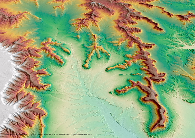
Airbus Defence: We have a lot of products and services derived from satellite imagery among them some are really innovative. WorldDEM, launched in 2014 is a good example. It consist in a new Digital Elevation Model (3D
representation of the Earth surface), derived from radar satellites acquisition, offering a complete and homogeneous pole-to-pole coverage, i.e. covering the entire Earth landmass (which represents about 150 Mio. km²), with a 12m posting. That means that WorldDEM (based on the German radar satellite TerraSAR-X and TanDEM-X) offers the same level of accuracy, wherever the location is. This is unique on the market, and provides a reliable and precise reference layer to enhance a wide range of applications.
This year we are launching two new products, One Tasking and One Atlas, both will allow our customers to easily access information when they need it.
With One Tasking, commissioning a satellite has never been easier. 30 years ago, Airbus Defence and Space revolutionised the satellite imagery market, being the first to offer tasking services. While strengthening our current competitive advantage on new collection, One Tasking sets a new industry standard.
We target the essentials: we commit to collect and deliver the imagery our customers need, when they need it. Our ambition is simple: making satellite tasking easier and faster than ever before.
E.E: What about the civil Engineering market?
A.D: Concerning the Civil Engineering market, One Tasking will help for example to plan the set-up of new infrastructure, to monitor its construction progress, but also to assess the risks, and prevent or recover damages.
With One Atlas, we offer an easy access to the world’s freshest basemap. One Atlas is a virtual globe that completely transforms the way satellite imagery is examined. This new service revolutionises how satellite images can be retrieved – online and on-demand from anywhere in the world. Every day, two million km² of fresh imagery is pushed to the platform. Users can access it with a single mouse click, a simple internet connection and without any specific imagery software simply from home.
Concerning the Civil Engineering market, One Atlas will help to perform preparatory studies for infrastructure planning, to define and adjust early routing or visualize, share and communicate infrastructures impacts.
E.E: Some stats about the market right now and future plans.
A.D: Airbus Defence and Space is a strong growth phase. We’ve grown at 10% per year over the last three years and this year we are expecting a step change in our performance outgrowing market. We keep growing our commercial business and diversifying our customer base. This has been made possible thanks to our unique optical & radar imagery portfolio and a compelling multi-satellite Direct Receiving Station offer.