Flota 3D is an innovative company whose core business is the creation of professional spatial imagery. Since its inception, the company has gained a reputation as a leader in geo-information data acquisition and analysis, offering comprehensive solutions based on the latest technologies such as 3D scanning, UAV and LIDAR.
Interview with Radosław Ganobis, Business Development Manager BIM/3D/LIDAR at Flota 3D Sp.z o.o.
Easy Engineering: A brief description of the company and its activities.
Radosław Ganobis: Our company focuses on providing high-quality services that meet even the most demanding customer expectations. The demand for the volume of geo-information data is constantly growing, which poses a significant challenge for many companies. In response to this need, Flota 3D invests in the latest technology and develops its expertise to meet the demands of the market. Our team is made up of skilled professionals from a variety of disciplines, including spatial surveying, geodesy and design, who not only have extensive theoretical knowledge, but also practical experience working with advanced tools and technologies. In addition to serving clients in the private sector, Flota 3D also carries out projects for government institutions, which confirms our credibility and the trust we enjoy in the market. We are passionate about creating accurate point clouds, inventories and BIM and MESH models, which are not only tools for our work, but also an expression of our commitment and professionalism in every project we undertake.
E.E: What are the main areas of activity of the company?
R.G: The main task of Flota 3D is the acquisition of spatial data using the latest technologies such as 3D laser scanners, UAVs and LIDAR. Our company specialises in analysing survey data and creating detailed documentation of the entire visible environment. These methods enable us to create precise and detailed point clouds, which are an indispensable tool in the planning, design and management of various facilities and infrastructure.
Our services are used across a wide range of industries and business areas, including:
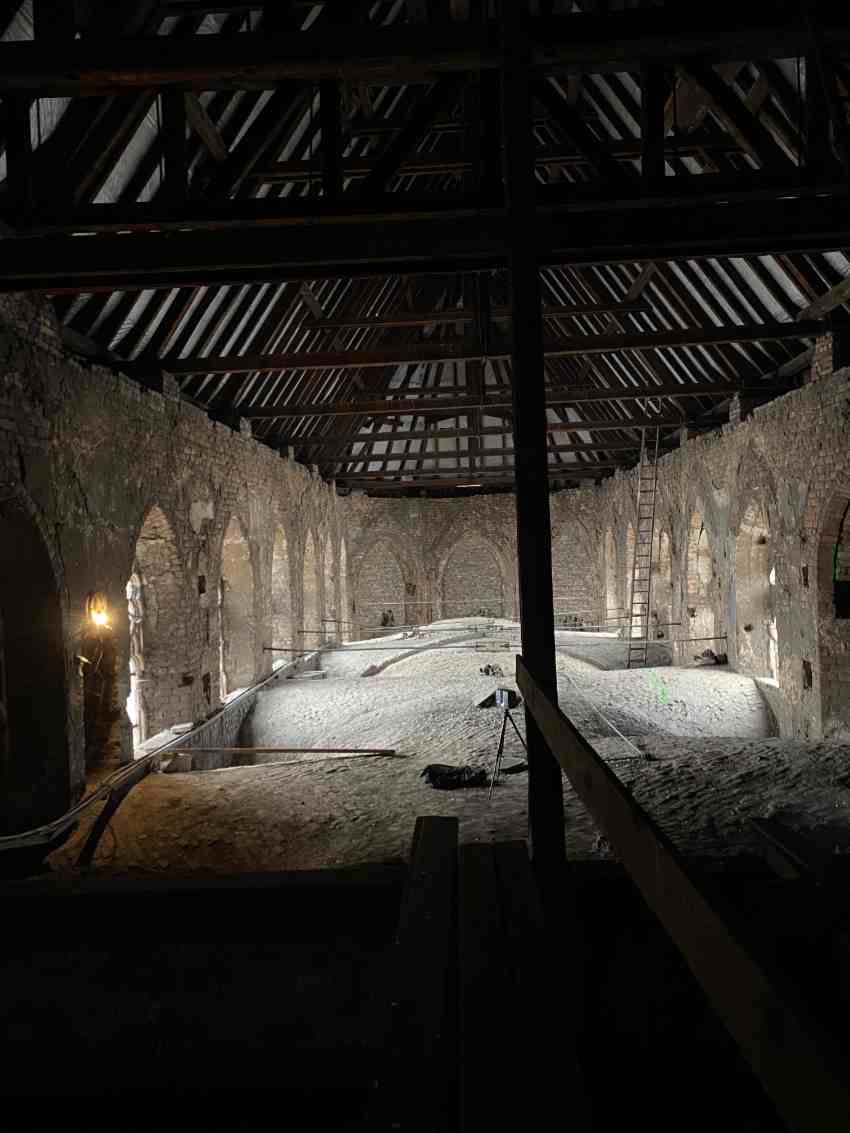
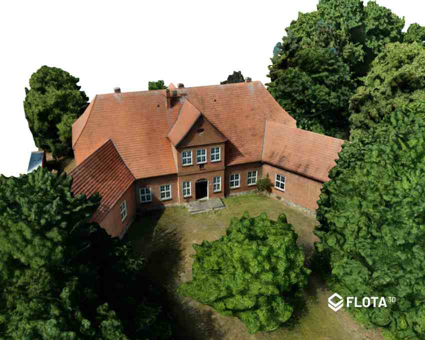
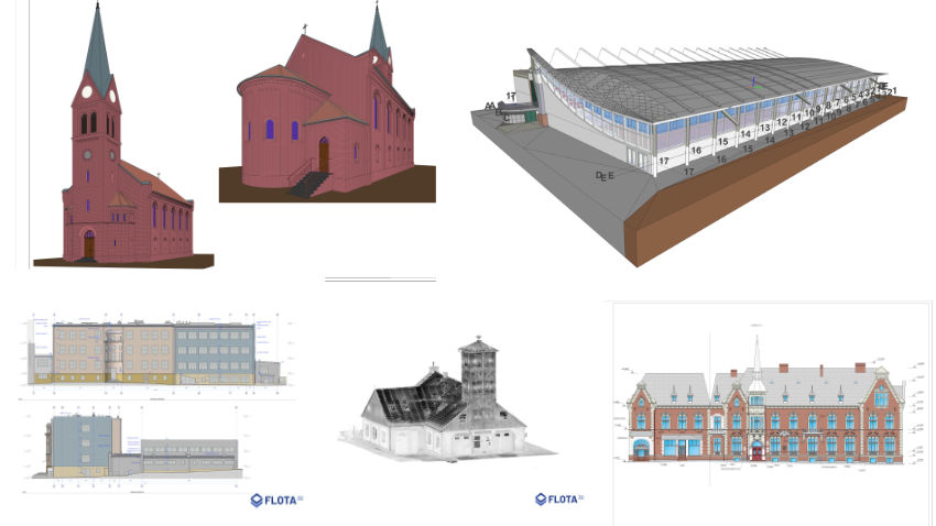
- Architecture: Creating 3D models of buildings, housing developments and infrastructure facilities. Monuments: Accurately reflecting the details and structure of historic landmarks, ensuring their preservation and documentation.
- Industry: Scanning of production lines, industrial halls and industrial infrastructure, with the aim of optimising production processes.
- Infrastructure: Mapping road, rail and energy networks, supporting urban infrastructure planning and management.
- Offshore industry: Extraction of data from offshore platforms, vessels and offshore installations, supporting offshore industry activities.
- Entertainment and Media: The use of spatial imagery in film production, computer games and virtual reality applications.
With advanced technologies and a highly skilled team, we are able to provide clients with comprehensive and high-quality solutions that meet their individual needs and expectations. Our aim is not only to provide services, but also to build lasting relationships based on trust and professionalism.
E.E: What’s the news about new products/services?
R.G: Keeping up with trends and innovations in the field of geo-information and spatial modelling, Flota 3D is constantly developing its offerings, introducing the latest technologies and solutions to the market. Our company invests in state-of-the-art scanners and measurement technologies, such as NavVis, which allow us to obtain data even faster and more precisely, increasing the efficiency of our work and customer satisfaction.
E.E: What are the ranges of products/services?
R.G: Flota 3D offers comprehensive geo-information and spatial modelling services, which include: Spatial data acquisition using 3D laser scanners, UAVs and LIDAR. Analysis of survey data and creation of detailed documentation. 3D BIM modelling in Revit and ArchiCAD environments. Data acquisition using unmanned aerial vehicles (UAVs) and aircraft with LIDAR, generating photogrammetric products. Our services are tailored to meet the diverse needs and requirements of our clients, and our team of experts provides support and advice at every stage of the project.
E.E: What is the state of the market where you are currently active?
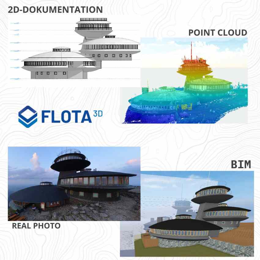
R.G: Currently, the market is witnessing rapid developments in the processing of laser scanning data into BIM models (Scan to BIM). Companies offering software for creating BIM models and users actively exploiting the potential of laser scan data acquisition are aware of the growing value and importance of this technology. We see a trend towards the increasing use of BIM models in various sectors, which is influencing the further development of this industry. Our goal as Flota 3D is to work closely with our clients to define their diverse needs and select the right tools and technologies that can effectively support their projects. In this context, continuous monitoring of the market and demand allows us to follow trends and catch interesting innovations that can be of value to our customers. Our aim is not only to provide services, but also to fully understand and support our clients in their business.
E.E: What can you tell us about market trends?
R.G: In our view, Building Information Modelling (BIM) is slowly becoming the industry standard. Modelling facilities using BIM provides a comprehensive and consistent approach to the design, management and delivery of construction projects. Using BIM models, we can accurately reflect real objects and their properties, making design work easier and more efficient at many stages of the construction process. Scanning objects and reflecting them with BIM models helps to improve the efficiency, precision and quality of projects. This enables engineers, architects and other professionals to better plan, analyse and coordinate their activities, resulting in time and cost savings for construction projects. We believe that the growing importance of BIM models will continue and this technology will play an increasingly important role in the future of the construction industry.
E.E: What are the most innovative products/services marketed?
R.G: The development of laser scanning technology primarily affects the quality and accuracy of data/information acquisition, which is later reflected in the form of BIM models. Innovation in our company through the implementation of laser scanning translates into an efficient organisation of the execution process.
E.E: What estimations do you have for the beginning of 2024?
R.G: Nowadays, the most important factor is to obtain as much information as possible in the shortest possible time. The time saved not only affects the design process, but also the execution process, which ultimately influences efficient communication during the realisation of the project. We estimate further intensive development of 3D technology and, consequently, of related products. We are putting the technology into practical use.