TOPODRONE is a Swiss based designer and manufacturer of high-precision surveying equipment for installation on UAVs, vehicles and backpacks. Their hardware (LiDARs, high resolution cameras, PPK and bathymetry solutions) are used for mapping and 3D modeling. Application areas include but are not limited to forest and agricultural monitoring, construction and urban planning, and bathymetry.
TOPODRONE’s advanced post-processing software provides users with easy-to-use innovative data processing workflows for automatic data generation, georeferencing and alignment using GNSS and IMU data post processing, and SLAM algorithms.
The company’s mission is to provide affordable and reliable solutions for surveyors all over the world. The HQ is based in Montreux, Switzerland; and they have a community of thousands of users globally who experiment and grow together with TOPODRONE advancing their portfolios and applying the newest surveying technologies.
Interview with Ilya Shikov is CTO at TOPODRONE.
Easy Engineering: What are the main areas of activity of the company?
Ilya Shikov: Back in 2018 we started as post-processing software developers and also integrated a GNSS receiver with an ordinary consumer drone – we transformed a tool called PPK that allowed us to turn an ordinary UAV into a true surveying device. Within a year in 2019 over 100 users practiced airborne photogrammetry surveying with small UAVs and high-precision TOPODRONE GNSS modules. We have been developing our in-house R&D from photogrammetry to LiDAR and bathymetry. Today we offer hardware and software solutions which have been developed by ordinary surveyors for other ordinary surveyors to improve time & cost efficiency as well as data accuracy.
E.E: What’s the news about new products/services?
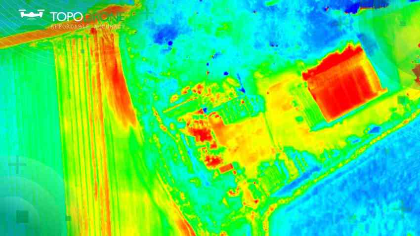
I.S: In December 2023 TOPODRONE released a new drone thermal mapping solution. TOPODRONE PT61 camera can perform detailed surveys and deliver thermal orthomosaic maps obtaining accurate 3D models. The new photogrammetry solution was initially developed in collaboration with AGROWING upon a request of a large enterprise client from North America and later on has been adjusted to a wider use of drone surveyors. It is a camera with 61 MP resolution and built-in thermal imager, and RGB lenses with different focal lengths, built-in GNSS module and IMU, as well as API for integration with any UAV. The combination of the PT61 camera with AGROWING’s multispectral lenses enables TOPODRONE to provide the camera as a dual-purpose RGB/Multispectral solution. The PT61 camera with Quad lens from AGROWING provides up to 14 multispectral bands with a resolution from 8 to 12 MP each, depending on the type of lens.
In addition, we have completed the integration of TOPODRONE LiDARs and cameras with INNOTECH VTOLs. The official partnership announcement will be made later this year.
E.E: What are the ranges of products/services?
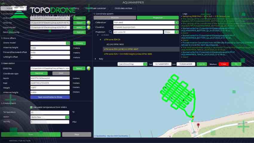
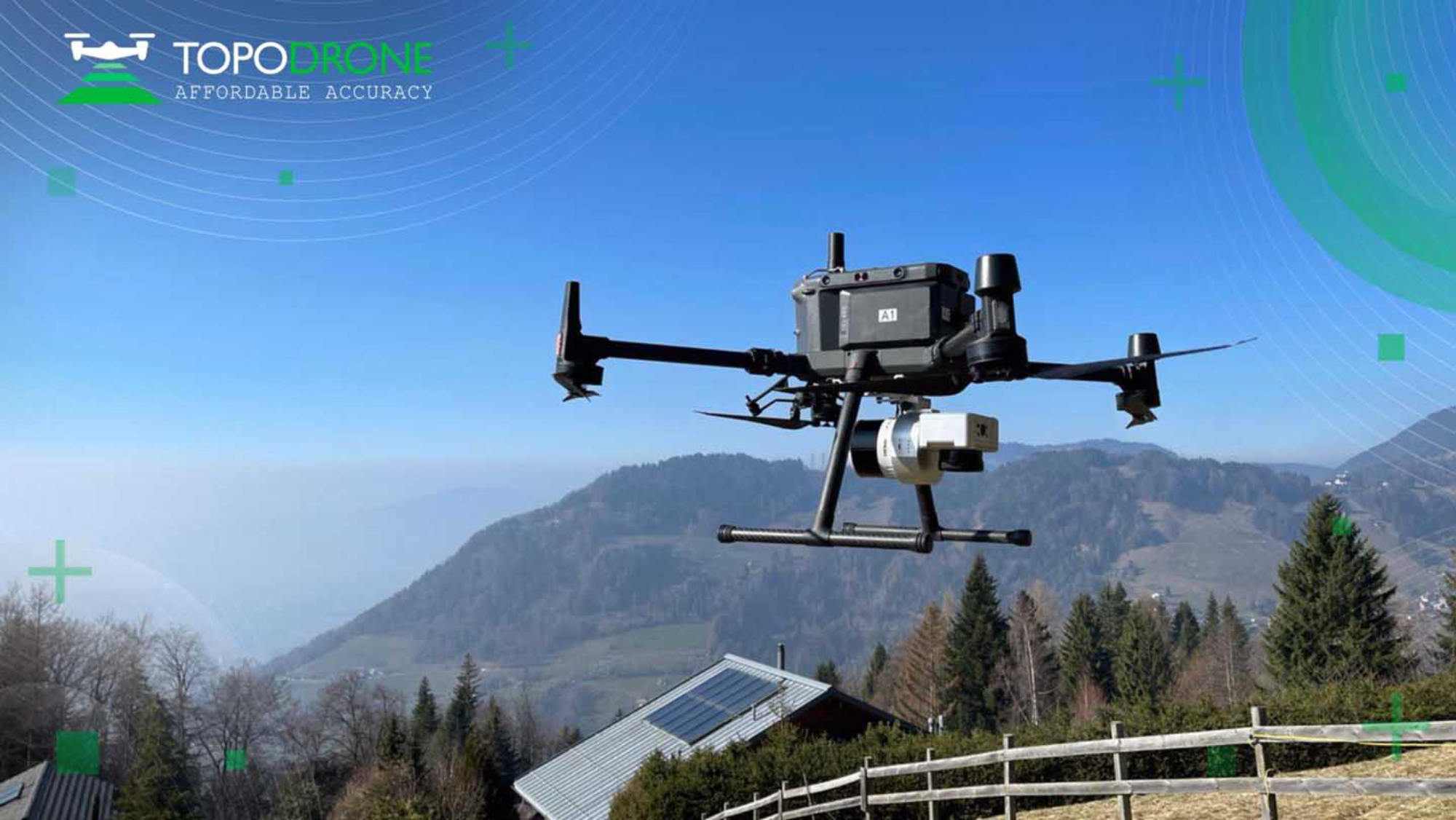
I.S: TOPODRONE offers photogrammetry hardware (P24, P61, PT 61 cameras), a lightweight 360° LiDAR model range (LiDAR 100, 100+, and LiDAR 200+), and AQUAMAPPER, a bathymetry device. Most of our LiDARs are Hesai-based and we also partner with other LiDAR producers globally. And all the hardware produced by us is supported by TOPODRONE Post-Processing software. TOPODRONE LiDAR 200+, in particular, is one of the lightest and most compact 360° LiDARs on the market. It can generate very precise and thin point clouds thanks to modern laser sensors, built-in high precision IMU and integrated GNSS receiver. One of its advantages is mobility: it is a true ‘LiDAR 3 in 1’ and can be mounted not only on a drone, a car and a surveying backpack. In addition, it is fully compatible with TOPODRONE P24 and P61 photogrammetric cameras, the camera can be connected to the laser scanner, a fixed installation on LiDAR, as well as an option with installation of the camera on a 3-axis gimbal. SLAM algorithms for data processing in conditions of insufficient GNSS signal are supported with our Post Processing Software.
E.E: What is the state of the market where you are currently active?
I.S: In 2023 we observed a slight decrease in demand from European surveyors, however, there was a noticeable sales boost in the Asian market, particularly in the APEC region for bathymetry solutions. The interest for surveying solutions, both airborne and mobile, was stable and rather high in North America.
E.E: What can you tell us about market trends?
I.S: TOPODRONE is a unique company. We neither focus on market research nor identify new trends – we create them ourselves based on our professional experience!
We challenged ourselves to enter the photogrammetry market with an easy-to-use PPK solution for UAVs. TOPODRONE developed a small device that turns an ordinary drone into a photogrammetry device. The photogrammetry community was very suspicious towards our solution. However, drone surveyors globally were open to testing the idea.
The interest in our PPK solution proven by thousands of sales all over the world inspired us to maintain the approach for developing affordable and accurate equipment. Later on, we experimented with more advanced tools: cameras, LiDARs, bathymetry hardware and also software. We test the equipment for our projects first in multiple scenarios taking into consideration both weather conditions and terrain. Then we regularly collect customer feedback and advance our solutions accordingly.
E.E: What are the most innovative products/services marketed?
I.S: The key R&D goal of TOPODRONE is to synchronize multiple data collection approaches: airborne & mobile for LiDAR surveying as well as photogrammetry, LiDAR and echo sounding technologies for drone bathymetry. Thus, a surveyor is able to apply multiple payloads for any type of airborne and mobile surveying and a post-processing software from 1 manufacturer – TOPODRONE. In this way, our company becomes an all-in-one support center for any type of surveying query. Our customers find not only products to purchase but also a professional partner with the global scale of projects.
E.E: What estimations do you have for the beginning of 2024?
I.S: Traditionally TOPODRONE products have been applied for following purposes: forest and agricultural monitoring, power line inspections, surveying for construction and urban planning, management of cultural heritage. In 2023 we saw increasing demand for our solutions in new application areas: renewable energy (solar panel farms and dams), mining (reservoirs and open pits), coastal management. This year we expect our existing customers to try themselves in new surveying areas while more gis experts and drone pilots globally to align multiple data collection approaches, including those with the use of TOPODRONE solutions. We expect to meet an increasing demand from universities and educational organisations and we are proud to keep support academic studies and research with the use of TOPODRONE technologies.