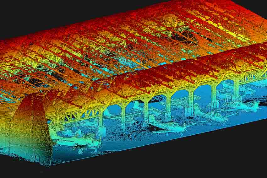
Aerial Precision designs and manufactures intelligence-driven LiDAR systems for commercial drones and mobile vehicles as well as all the accompanying software to process and analyze the data captured by the sensor. The company’sfocus is to provide information ready to be used in decision-making processes, and this information is extracted in real time from the sensors’ spatial data (point clouds). Thus, customers can install the LiDAR sensors in commercial unmanned aircrafts and agricultural vehicles and use them for various purposes.
Easy Engineering: What are the main areas of activity of the company?
Aerial Precision: Aerial Precision operates in the area of mapping and topographic survey of surfaces. Its technological solutions can provide data with a diversified use, from agriculture to land planning, geological studies, and preparation of civil construction projects, as well as for civil protection and other purposes.
E.E: What is new about the new products?
Aerial Precision: Our products stand out because they are the first Intelligence-Driven Lidar System and are User-Friendly. You do not need to understand much about LiDAR sensors to be able to use them, you only need to scan, and the app will give you all the information, with the advantage of accessing and using it, for decision-making, in real-time.

E.E: What are the product ranges?
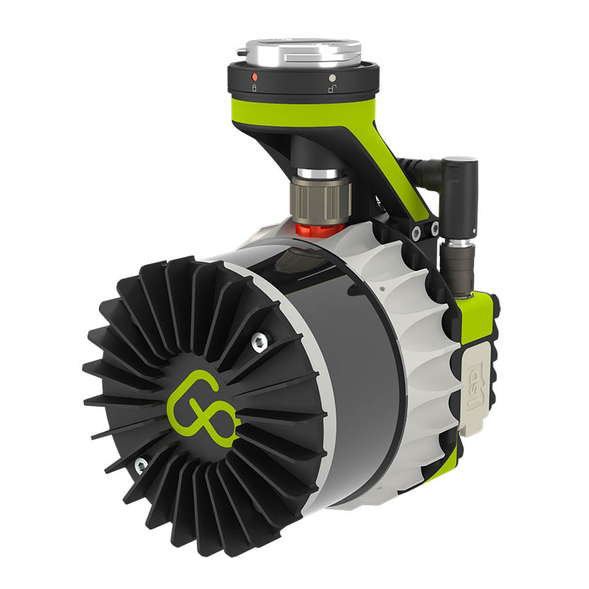
Aerial Precision: AP-LiDAR-One and AP-LiDAR-M – Your First Intelligence-Driven Lidar System For Enterprise Drones
Two ccomplementary products, but which stand out in the market for being cost-effective, with different applications. For example, if you want to use it for construction, you should choose the AP-LiDAR-One, but if you want to use it in agriculture, our AP-LiDAR-M is the right one.
Both have very similar features since they are light and don’t need extra components or expensive INS systems to connect them to a drone.
Our sensors main differentiating factor is having their ata in real-time. You do not have to wait for post-processing to make relevant decisions, knowing that for management, today more than ever, time is money.This performance is possible thanks to our proprietary AP-SLAM architecture.
With support for external storage on a micro SD Card, you will always have space, however long your mission is, and you don’t have to worry about an internet connection.
The AP-LiDAR-One can be equipped with two different LiDAR configurations, either 32 or 64, which means that for your desired point-cloud density, the more channels, the faster you can fly and complete projects in a fraction of the time.
Although it is more focused on drones, you can easily use our sensors on a tripod, in your car, or even in your hand.
Besides the sensors, we produce and keep in constant development and evolution of our App, where you can control and know all your data from your portable equipment, computer, or tablet.
E.E: At what stage is the market in which you are currently active?
Aerial Precision: The market is in a race against time, and there is a lack of fast, precise, and accessible solutions to improve the quality and quantity of the data collected and available, to reduce the time until the use of the information in the decision process, to lower prices and improve user-friendly performance in the handling of equipment and use of applications. And this is the gap that Aerial Precision comes to fill in the market, offering more accessible solutions with real-time processing, providing reliable and quality results, and increasing the potential competitiveness of its customers. Through our solutions, our customers can make real-time decisions based on information that is a critical factor for the success of their business.
E.E: What can you tell us about market trends?
Aerial Precision: The market tends to value and prefer the most cost-effective, user-friendly solutions that facilitate decision-making in the shortest possible time.
E.E: What are the most innovative products on the market?
Aerial Precision: Our products continue to be the most innovative in their segment, taking into account the competitive advantages they offer customers compared to what the competition can offer them, namely the possibility of using data in real-time and the price factor, which is unquestionably more accessible, plus easy and user-friendly handling.
E.E: What estimates do you have for 2023?
Aerial Precision: 2023 will be the year of affirmation of our brand and consolidating our positioning in our market segment.