GeoKinesia is a technological startup from Barcelona, Spain created under the Collider acceleration program (2020 edition) with the participation of the Center Tecnològic de Telecommunications de Catalunya (CTTC), a world leading research center in the field of telecommunications and geomatics. CTTC transferred its InSAR technology to GeoKinesia.
Interview with Pavel Pavlovsky, Chief Executive Officer at GeoKinesia.
Easy Engineering: What are the main areas of activity of the company?
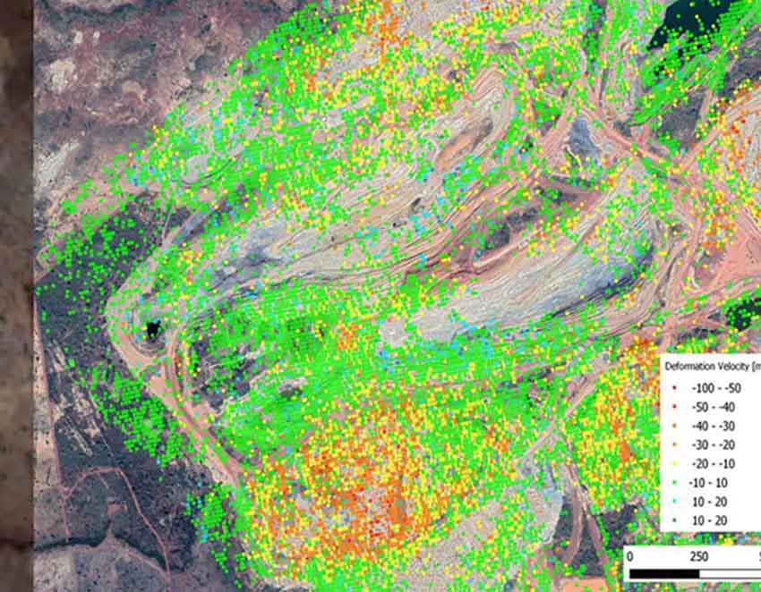
Pavel Pavlovsky: Synthetic Interferometric Radar (InSAR) is a remote sensing technique that uses data from satellites to detect, measure, and predict Earth deformations.
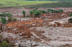
Ground deformations are a major problem for mining, oil and gas, civil engineering, and other industries, as well as for infrastructure and habitational areas. Landslides claim thousands of lives every year, e.g. an accident at a copper mine in Brumadinho (Brazil) in 2019 killed more than 280 people.

We exploit and develop an InSAR technology and render deformation monitoring service to large accounts in the mining and oil & gas sectors, but we will gradually shift our focus towards collaborations with geotechnical, asset monitoring and earth observation companies, we are especially interested in infrastructure monitoring services.
E.E: What’s the news about new products?
P.P: We possess one of the best InSAR processing chains and InSAR service experience int he world but relentlessly work on the product improvement. In particular, we are one of the world frontrunners trying to adopt Deep Learning algorithms to the InSAR processing chain – the task of high complexity requiring extensive R&D.
In consortium with 4 research institutions, we also work on a project, which aims to develop a highly innovative infrastructures monitoring predictive solution which make use of the intelligent remote sensing monitoring data and InSAR in particular and digital dynamic modelling of terrain and structures.

Pavel Pavlovsky
We also recently introduced two downstream value-added products for European Ground Motion initiative (EGMS), namely Active Deformation Areas Map – an easy-to-use map of deformations in Europe and also Differential Deformation Map – an electronic service which allows experts to analyse the differential – a difference in levels – of a deformation, which may affect their objects of responsibility and pose a risk.
E.E: What are the ranges of products?
P.P: We provide InSAR monitoring and other value added products mentioned above. We work with all data providers – High resolution and also medium to low resolution data but primarily with Copernicus – an ESA’s satellite program, Sentinel-1 satellites.
E.E: At what stage is the market where you are currently active?
P.P: InSAR market is a young and quickly growing market segment of the earth observation market. The technology has become de facto a standard in the mining industry with majority of the leading companies such as BHP, Anglo-American, Glencore etc. using it across their operations but its penetration in civil engineering and construction is still low but grow at a fast pace. The technology is also actively used in geohazards monitoring and civil protection but mostly in Europe, other markets and especially markets in Asia, Latin America, Africa represent a huge opportunity.
We expect the market to grow 5-10 times in the next 10 years.
E.E: What can you tell us about market trends?
P.P: The key trends, we believe, are the growing penetration of the technology especially in the sectors outside of the mining industry. More and more practitioners learn how to use the technology. We also believe that a data fusion and synthesis of InSAR and other remote sensing data with in situ instrumentation data will bring new insights to practitioners and support their risks monitoring practices.
We see the price for the service is going down and we also expect that the price for the satellite data will see some reduction in the future.
The marriage of the InSAR processing with AI, which we are advancing, is definitely a trend.
New satellite data providers such as Capella Space and Iceye bring higher resolution data with daily revisit time – something, which should yet find a good use case in the future.
E.E: What are the most innovative products marketed?
P.P: InSAR technology is a result of a long and complex innovation process. The first radars were developed back in the 1950s, while the first spaceborne radars hit the orbit in the beginning of the 90s and only in early 2000s reliable processing software tools and methods have been developed and are improved since.
InSAR based early warnings and predictions, which we work upon, is going to be one of the most innovative offerings on the market.
E.E: What estimations do you have for 2023?
P.P: Although the macroeconomic environment remains challenging we expect some significant growth in our target market. We also expect to see a strong revenue growth as we have signed a large number of contracts in 2022, most of them long term, and also signed a large number of pilots and high potential customers in the beginning 2023. Our MRR shows sharp increase and our ARR will be 100% or more up from 2022.